TRENDS | With the recent debut of GPS services for business in Jordan, Ahmad Humeid wonders if we’ll be enjoying electronic city navigation anytime soon.
I only remember how big Amman has become when I visit a relative in a part of town I haven’t been to. Amman is big and is expanding in all directions. And with the flurry of investments into real estate mega project the city is about to become even bigger.
Still, as a dwellers of a city in the ‘developing world’, we Ammanis still think we live in a little village. We still give addresses in the form of: “take the fourth U turn after the supermarket, then the third street on your right, count 4 houses after the pharmacy, our house is the one with a blue Honda parked in front of it”.
This is especially frustrating when you try to order a pizza delivery. “Err, the guy who used to deliver to you left his job, so can you please give us driving instructions again, sir?”.
With the advent of mobile phones, Jordanians have proved they can ‘harness technology’ to overcome the challenges of everyday life. Once our guests arrive at a major road intersection, they call us from their mobiles and we, sitting at home, accompany them all the way to our front door, remote driving them through the streets until we can see them from the veranda and say “I see you. I see you! You can stop now”, while we greet them from the 4th floor with a wave of our hands. Charming.
Is there a better way?
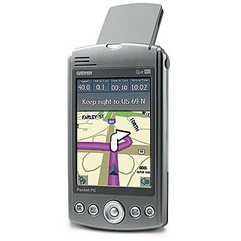
In Germany, where I was last month, the latest consumer electronic hit seems to be Global Positioning System (GPS) navigation devices. Now GPS is not exactly something new. The whole system has been developed in the seventies and there have been handheld as well as car mounted GPS systems for quite a while now.
Using the signals from 3 or 4 satellites (from a total of around 24 satellites which constantly orbit the earth) a GPS receiver can accurately determine your position anywhere on earth. Add an accurate electronic map and some intelligence and you get a device that can tell you how to drive or walk from one place to another.
What’s new is that the market is being flooded with GPS navigation products in all shapes and sizes: from dedicated car-based systems from, to ones that can connect to your mobile phone or PDA via Bluetooth (check out the website of Gramin and Tom Tom to explore this GPS world).
The visual display of maps has also improved a lot. Users can choose from normal 2D map views or 3D displays which give you a better understanding of the roads and surroundings. Any good GPS navigator now can give you voice driving instructions, alert you to up to date traffic information, and show you points of interest such as hotels, restaurant and gas stations.
Jordan and the Arab world: A GPS desert?
Let’s leave the satellites up in the sky and get down to earth. Jordan and most of the Arab world has been left behind when it comes to GPS navigation. The problem is not with GPS technology, but with the lack of electronic maps for our countries and cities. A quick Google search reveals that the Gulf States (especially Bahrain) are in a better situation. Electronic maps of Jordan showing the road network and the major tourism spots are available, but I could not find anything for Amman or other Jordanian cities.
When you consider that Amman still doesn’t have a traditional, paper based proper driving map, the prospect of getting GPS navigation for Amman seems like a far fetched dream. Or is it?
GPS services make a debut in Jordan
Xpress telecommunications has recently announced its XGPS system. The launch was targeted at companies who have car or truck fleet management requirements (think trucking, courier and taxi companies). The company says that this is a first, not just for Jordan, but for the entire Arab region.
For now, this is a service targeted at businesses and we might be still far away from enjoying GPS city navigation.
But as Amman and other Arab cities grow and acquire a more sophisticated road network, a clear opportunity is on the horizon: the development of GPS navigation oriented electronic maps and Arabized navigation systems. This could be an opportunity taken up by Jordanian entrepreneurs. Amman can be the testing ground for someone who is thinking of properly introducing such services in the region.
Just remember: if people are really to rely on a Jordanian GPS navigations system, it really needs to be accurate, comprehensive and up-to-date. It needs to know, just for example, which streets in Jabal Luweibdeh are one way.. and in which direction they goes!
Some GPS facts
Source: Wikipedia
The original GPS system was designed by and is controlled by the United States Department of Defense and can be used by anyone, free of charge. Maintaining the system which consists of 24 satellites as well as ground stations cost around US$ 400 million a year.
Because the US Military reserves the right to shut limit access to the system or even shut it down completely in times of war, the European Union has proposed it’s own system, dubbed Galileo. There has been some political wrangling between the US and Europe concerning the project, as the US would have liked to maintain control over such services, especially in times of war.
Nonetheless, Europe is going ahead with its 30 satellite system. Launching of satellites will start in 2006 and the system is expected to be operational in 2008.
In September 2003, China joined the Galileo project. China will invest € 230 million (USD 296 million, GBP 160 million) in the project over the next few years. In July 2004, Israel signed an agreement with the EU to become a partner in the Galileo project. On 3 June 2005 the EU and Ukraine initialed an agreement for Ukraine to join the project. There is speculation that other countries might join the Galileo project, including India, Pakistan, Brazil, Mexico, Chile, Japan, Russia, South Korea, Australia, Morocco and Canada.
One of the latest GPS trends is the recording of a travel path on a GPS device, then saving it as a GPX file. This file can be then loaded into the Google Earth application, enabling the simulation of the trip as a fly over.
Comments
17 responses to “Amman: Waiting for GPS”
Oh, God. Jabal Il Weibdeh.. the nightmare! We need a REALLY good GPS navigation map to be able to figure ras il weibdeh min ejreiha! I’ve been to the National Gallery countless times and I still manage to get lost for at least 20 minutes every time I go.
East Amman is also absolutely horrible for navigation..
Dude, don’t even get me started. I was looking all over the place for an electronic map of Amman for a school project. Lol what a waste of time!
Forget about GPS, maybe it’s time to stop giving addresses by means of landmarks! What is really sad, that most homes and streets in Amman got a numbering system and a postal code, but no body knows about it, or even use it.
Only when there is a strong commercial demand for this service , the private sector will take serious steps to acquire it.
I remember once a cab driver asked me if I know where Rama Hotel is? I was I’m sorry, but u could always call the phone directory…lol he started whinning about my suggestion that it is too complicated and a waste of time, he said he’ll keep asking people that is the guratneed way, he had to be there at 4pm, and it was already 3:20pm lol
Jordan: GPS in Jordan
Ahmad Humeid wonders if Jordanians will be enjoying electronic city navigation anytime soon.
…
So, why not lead an online campaign to get people to input the gps readouts of various sites and landmarks in Amman? Do it as a wikipedia-like effort.
Electronic
GIS basedmaps with detailed streets and POIs (points of interest) are available for virtually all corners of the earth… if you are willing to pay the price that is!a decent 25 meter clutter map (meaning that the level of map details is sampled every 25m, can be obtained for Jordan for a hefty USD 25k.
The big players in the GPS market –such as Garmin- should take the initiative to produce subsidized digital maps for Jordan
should we also add Arabizedand other regions, but with the lack of a solid business case to make such maps accessible to the paying consumer – yet alone the general public- the uptake of GPS is dependant on the GPS pioneers of JordanUntil then, Point-to-Point navigation is good enough, given that you have a wealth of potential GPS users who have not yet exploited the GPS feature of their phones, chiefly, XPress users as all XPress phones are GPS enabled, with the top models have Java-based navigation software.
To the credit of a Jordanian GPS entrepreneur, a startup company called GPSJordan
bitten the bust 2 years agodid a great job in field surveys, and have in their database almost every corner of Jordan and especially greater Amman (including the odd falafel shaq in eastern Amman that everyone seems to think he made a novel discovery for finding the place). where is this data? if I was the guy behind the company I’ll be kind enough to publish the data in it’s crude form for the general public (easy to say given I have not invested thousands collecting the data in the first place).Well, I agree with William to lead a campaign to get people into this issue.
First of all, this campaign shouldn’t necessarily be an online campaign and it can be implemented by any sources available.
Well, guys… if we are to start something, lets start it for real.. why not to meet or first beginning by making our online group (maybe by yahoo) and see what are the fundamentals we need and resources we have. Who knows, what we can end up with.. it can be non-profit or turn to a profit.
Thanks to Ahmed who started this.
I’ll leave in my email and wait to hear from people who would like to participate in this.
You can find me here
Good luck
Hallo every body,
im a german, and at the moment in Dubai looking for a besniss. Like Mr. Ahmed i have the same experience in Dubai. No Taxi driver could take me to a defind place without to asking me how he has to drive
so thats why im interssted to commerce with Navigationssystems in this coutry.
If any one want to shar me this besniss, so please connect me under the Adress-Nr.:
PC: im so sory because of my bad englisch.
Traslation in german langueg:
Hallo leute,
ich ein deutscher, und z. Zt. in Dubai nach der Suche nach Geschaefts-Ideen. Auch ich habe die gleichen Erfahrungen, wie Herr Ahmad Humeid gemacht. kein Taxi-Fahrer koente mir zu einer bestimmten Adresse bringen, ohne, dass dieser mich nach den Weg, den er schlagen sollte zu fragen.
ich denke, dass die tatsache, dass die Verbreitung vom GPS in der arabischen Welt so gut wie nicht vorhanden ist, eine Marktluecke ist. Ich moechte gerne daher versuchen diese Marktluecke zu schliessen, daher die Bitte, wer Intersse hat mit mir dieses Geschaeftsfeld zu erobern sich bei mir unter: zu melden. mfG
sallam mo alekom
dear, ahmed do u no if there will be a navigation system cd for cars any time soon plz who evere reeds this email me ansers @
sallam mo alekom
allah ma’akom
Hi! So i`m aswell tried to find even one map for such a nice city like Amman, but the best i found was only google erth. Ok… i`m not a professional in GPS , but soon i`ll be in amman and i hope to meet smbd who will help me to coordinate OZI EXPLORER MAP.
there are map available for all streets in amman, its just you cant have gps locators in jordan without certain approvals or if u smuggle them in… this is why it will never work in jordan…take it from someone who tried this…
hi am laith u can help me if there are programming languge gives the ability to draw electronic map “simple map”and the map be active….help me if u can please…
blelaith@yahoo.com
Well,
One thing can be used is the Google Navigator which requires an access to internet as the images are retrieved from internet while driving.
Oziexplorer is also an option
Chek my post, I´m collecting POI and other information about Jordania and Amman http://www.foromtb.com/showthread.php?t=309601
We can make maps for free.
salam guys,
i have been looking for a map for jordan too… and the best source so far was from the amman municipality. they provide detailed jpg maps for most of amman areas (by district).
http://www.ammancity.gov.jo/arabic/maps/newmap.asp
so, if we want to have something going, we need to paste them together as a first step, and secondly a software that would utilize the fact that roads a distinctly yellow to provide some basic type of turn-by-turn navigation.
let’s work on this together and see where we can from here.
salam alikum aim going to jordan in 2 week its any way you could use navigotor system there and how please lete me know if some body know how and salam
NAVTEQ has finished the map of jordan
visit this site
http://corporate.navteq.com/webapps/NewsUserServlet?action=NewsDetail&newsId=757&lang=en&englishonly=false